
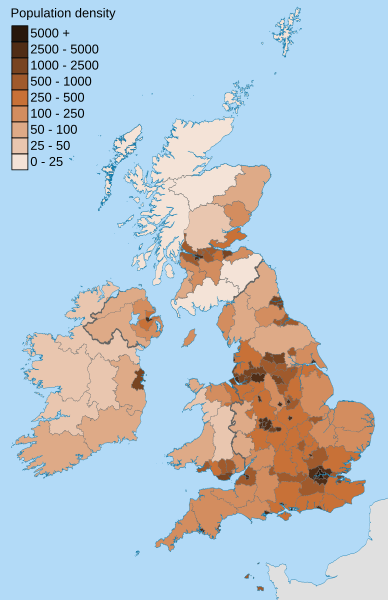
Image: British Isles population density 2011 NUTS3

Description: Map showing the population density of the British Isles in 2011, within the NUTS 3 subdivisions.
Title: British Isles population density 2011 NUTS3
Credit: Population data is from the 2011 censuses for the United Kingdom, Ireland, the Isle of Man and Jersey, and the 2011 population estimate for Guernsey. Background map: Ordnance Survey OpenData Boundary-Line: GB data National Geospatial-Intelligence Agency Other data
Author: Nilfanion, created using Ordnance Survey data
Permission: This file is licensed under the Creative Commons Attribution-Share Alike 3.0 Unported license. Attribution: Contains Ordnance Survey data © Crown copyright and database right You are free: to share – to copy, distribute and transmit the work to remix – to adapt the work Under the following conditions: attribution – You must attribute the work in the manner specified by the author or licensor (but not in any way that suggests that they endorse you or your use of the work). share alike – If you alter, transform, or build upon this work, you may distribute the resulting work only under the same or similar license to this one. http://creativecommons.org/licenses/by-sa/3.0 CC BY-SA 3.0 Creative Commons Attribution-Share Alike 3.0 truetrue
Usage Terms: Creative Commons Attribution-Share Alike 3.0
License: CC BY-SA 3.0
License Link: http://creativecommons.org/licenses/by-sa/3.0
Attribution Required?: Yes
Image usage
The following page links to this image:
