
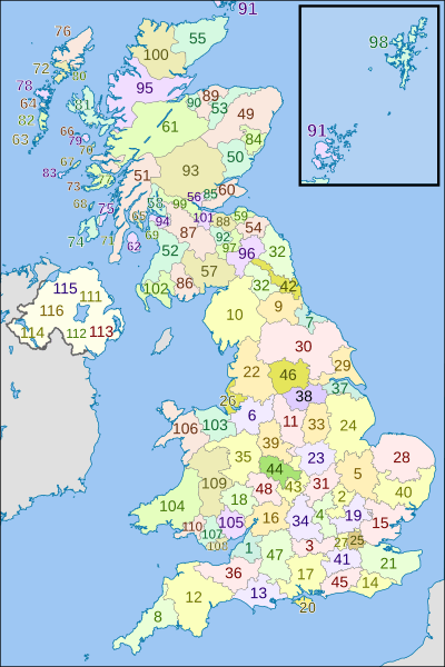
Image: British former postal counties (numbered)

Size of this PNG preview of this SVG file: 400 × 600 pixels. Other resolution: 160 × 240 pixels.
Original image (SVG file, nominally 690 × 1,035 pixels, file size: 1.02 MB)
Description: Map of Royal Mail former postal counties of the United Kingdom.
Title: British former postal counties (numbered)
Credit: This file was derived from: British postcode areas map.svg: AB postcode area map.svg: and all the other maps of the form "XX postcode area map.svg" by Richardguk
Author: British_postcode_areas_map.svg: Richardguk AB_postcode_area_map.svg, etc: Richardguk derivative work: Dr Greg
Usage Terms: Creative Commons Attribution-Share Alike 3.0
License: CC BY-SA 3.0
License Link: http://creativecommons.org/licenses/by-sa/3.0
Attribution Required?: Yes
Image usage
The following page links to this image:

All content from Kiddle encyclopedia articles (including the article images and facts) can be freely used under Attribution-ShareAlike license, unless stated otherwise.
.svg)