
Image: BroutinMargotCloseup
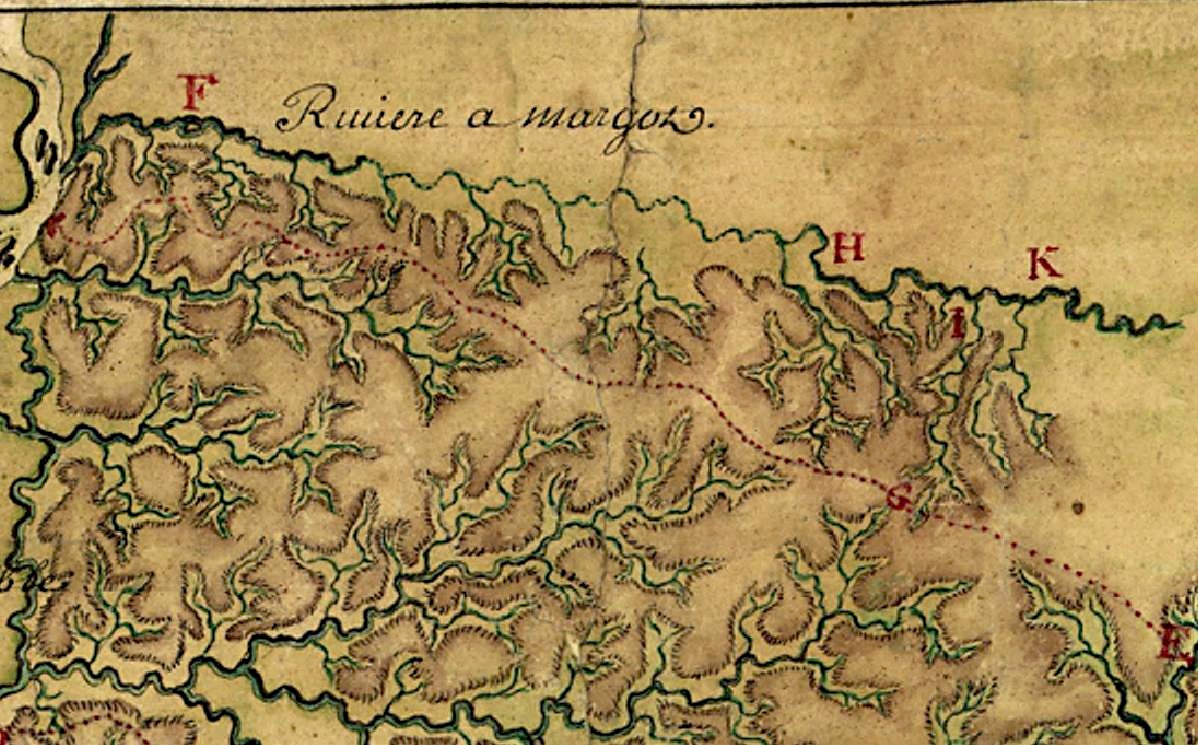
Description: The watershed of the Riviere a Margot (now called Wolf River) in 1740. Everything above the red dotted line (a Chickasaw trail) is part of the Wolf River. Detail from the map Carte particulière d'une partie de la Louisianne ou les fleuve et rivierres onts etés relevé a l'estime & les routtes par terre relevé & mesurées aux pas, par les Srs. Broutin, de Vergés, ingénieurs & Saucier dessinateur. Drawn by a cartographer who only signed the name "Demarigny," the map concentrates on the surveys of Broutin, Vergés, and Saucier in Mississippi and Alabama. "Demarigny" was probably Antoine Phillipe, Sieur de Marigny, Chevalier de St. Louis (1722-1779), a New Orleans-based geographer and explorer. Whether or not the composite map was drawn by Antoine Phillipe, this specific map detail is based on surveys by his step-father, Ignace François Broutin, Capitaine Ingénieur du Roi [chief engineer of the Louisiana colony] during the Chickasaw Campaign of 1739-40. Broutin accompanied Jean-Baptiste Le Moyne, Sieur de Bienville, governor of Louisiana, up the Mississippi River on this military expedition and was charged with building fortifications (Forte d e l'Assumption on the Fourth Chickasaw Bluff at the mouth of the Margot River) and finding a way to move heavy siege weapons from Fort Assumption to, Ackia, the Chickasaw stronghold near present-day Pontotoc, Mississippi. A cannon-less Bienville suffered a bloody defeat at Ackia in 1736. Existing trails proved unsuitable for heavy wagons, so Broutin explored a water-route via the Margot (now the Wolf River) after a small group of young Iroquois mercenaries reported for duty at Ft. Assumption via the Margot, claiming that one of the river's branches extended to within 8 leagues of the Chickasaw villages. Broutin's party of French grenadiers and African slaves attempted the survey during the Wolf River Watershed's low water season (February) and encountered too many fallen trees snagging the channel. Before spring rains could raise the water level, Bienville secured a peace settlement with the Chickasaw and returned to New Orleans. The other watersheds depicted on this map detail, moving north to south, include Nonconnah Creek and the intricate Coldwater River system. A branch of the Little Tallahatchie is seen at the lower right corner, although it is identified by Broutin as the Riviere des Yasoax (Yazoo). The Little Tallahatchie does, however, flow into the Yazoo much further south.
Title: BroutinMargotCloseup
Credit: Library of Congress (the original chart was purchased during "personal visit to the foreign markets" by Philip Lee Phillips, Chief, Division of Maps and Charts, ca. 1905-06). Full map viewable at http://memory.loc.gov/cgi-bin/query/h?ammem/gmd:@field(NUMBER+@band(g4010+ct000681))
Author: "Demarigny" (probably Antoine Phillipe de Marigny) and Ignace François Broutin
Usage Terms: Public domain
License: Public domain
Attribution Required?: No
Image usage
The following page links to this image:
