
Image: Bussell-island-vicinity-tn1
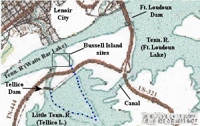
Description: Map showing the original outline of Bussell Island, at the junction of the Tennessee River and Little Tennessee River near Lenoir City, Tennessee, USA. The construction of Tellico Dam in the 1970s flooded the original southern 2/3rds of the island, and a mile-long earthen levee was built along the island's new southwest shore and across its east river channel, connecting the island with the mainland. The construction of the canal between Tellico and Fort Loudoun lakes effectively created a larger island. The Bussell Island sites were excavated in 1887 and 1919.
Title: Bussell-island-vicinity-tn1
Credit: United States Geological Survey – National Map
Author: United States Geological Survey; Brian Stansberry
Usage Terms: Public domain
License: Public domain
Attribution Required?: No
Image usage
The following page links to this image:
