
Image: Byzantine Constantinople-en

Size of this preview: 664 × 599 pixels. Other resolutions: 266 × 240 pixels | 3,200 × 2,888 pixels.
Original image (3,200 × 2,888 pixels, file size: 2.35 MB, MIME type: image/png)
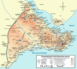
Description: Topographical map of Constantinople during the Byzantine period. Main map source: R. Janin, Constantinople Byzantine. Developpement urbain et repertoire topographique. Road network and some other details based on Dumbarton Oaks Papers 54; data on many churches, especially unidentified ones, taken from the New York University's The Byzantine Churches of Istanbul project. Other published maps and accounts of the city have been used for corroboration.
Author: Cplakidas
Usage Terms: Creative Commons Attribution-Share Alike 3.0
License: CC-BY-SA-3.0
License Link: http://creativecommons.org/licenses/by-sa/3.0/
Attribution Required?: Yes
Image usage
The following 5 pages link to this image:

All content from Kiddle encyclopedia articles (including the article images and facts) can be freely used under Attribution-ShareAlike license, unless stated otherwise.