
Image: California Pleistocene Lakes USGS

Size of this preview: 642 × 600 pixels. Other resolutions: 257 × 240 pixels | 2,756 × 2,575 pixels.
Original image (2,756 × 2,575 pixels, file size: 57 KB, MIME type: image/png)
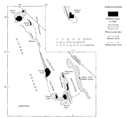
Description: Map showing the system of once-interconnected Pleistocene lakes in eastern California (USGS)
Title: California Pleistocene Lakes USGS
Credit: US Geological Survey Professional Paper 1043, "Subsurface Stratigraphy and Geochemistry of Late Quaternary Evaporites, Searles Lake, California
Author: George I Smith
Usage Terms: Public domain
License: Public domain
Attribution Required?: No
Image usage
The following 6 pages link to this image:

All content from Kiddle encyclopedia articles (including the article images and facts) can be freely used under Attribution-ShareAlike license, unless stated otherwise.