
Image: Caribbean Sea Gulf of Mexico shaded relief bathymetry land map

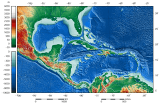
Description: The shaded relief bathymetry and land map of the Caribbean Sea and Gulf of Mexico area. The map was created using the Generic Mapping Tools, GMT, version 5.1.1.
Title: Caribbean Sea Gulf of Mexico shaded relief bathymetry land map
Credit: Own work using: the following Public Domain datasets for the relief: http://www.ngdc.noaa.gov/mgg/topo/gltiles.html GLOBE (topography, land part of this map) Credits: National Geophysical Data Center, 1999. Global Land One-kilometer Base Elevation (GLOBE) v.1. Hastings, D. and P.K. Dunbar. National Geophysical Data Center, NOAA. doi:10.7289/V52R3PMS [access date: 2015-03-16]. http://www.ngdc.noaa.gov/mgg/global/global.html ETOPO1 Global Relief Model (topography/bathymetry, bathymetry part of this map) Credits: Amante, C. and B.W. Eakins, 2009. ETOPO1 1 Arc-Minute Global Relief Model: Procedures, Data Sources and Analysis. NOAA Technical Memorandum NESDIS NGDC-24. National Geophysical Data Center, NOAA. doi:10.7289/V5C8276M [access date: 2015-03-18]. Created with Generic Mapping Tools (GMT)
Author: Darekk2 using the ETOPO1 and GLOBE tiles
Usage Terms: Creative Commons Attribution-Share Alike 4.0
License: CC BY-SA 4.0
License Link: http://creativecommons.org/licenses/by-sa/4.0
Attribution Required?: Yes
Image usage
The following 2 pages link to this image:
