
Image: Carte allobrogie

Size of this preview: 519 × 599 pixels. Other resolutions: 208 × 240 pixels | 953 × 1,100 pixels.
Original image (953 × 1,100 pixels, file size: 283 KB, MIME type: image/png)
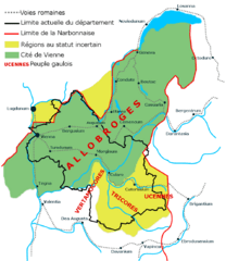
Description: Carte des peuples gaulois en Isère réalisée par moi-même (Pedro38) avec Gimp sur le modèle de « La cité de Vienne : Un vaste territoire », Atlas du patrimoine de l’Isère, p41, édition : Glénat.
Title: Carte allobrogie
Credit: Own work
Author: Pedro38
Usage Terms: Creative Commons Attribution-Share Alike 3.0
License: CC BY-SA 3.0
License Link: http://creativecommons.org/licenses/by-sa/3.0
Attribution Required?: Yes
Image usage
The following page links to this image:

All content from Kiddle encyclopedia articles (including the article images and facts) can be freely used under Attribution-ShareAlike license, unless stated otherwise.