
Image: Castell coch woodlands sssi map

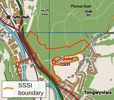
Description: Map showing the limits of the Castell Coch Woodlands and road section SSSI, using the following colour scheme for additional information shown: Motorways Primary routes Non-primary A roads B roads Minor roads Railways Water Woodland Buildings OS map projection (nb: Not WGS 84 datum) with OS 1km grid squares shown. SW origin is ST124821 Geographic limits: W: -3.2658 E: -3.2438 N: 51.5424 S: 51.5313
Title: Castell coch woodlands sssi map
Credit: Ordnance Survey OpenData viewer VectorMap District product (raster version) 2011. SSSI information from www.ccgc.gov.uk
Author: RobinLeicester created using Ordnance Survey data
Permission: Note: Derivative works can be licensed under any Creative Commons Attribution 3.0 Licence.
Usage Terms: Ordnance Survey OpenData Licence
License: OS OpenData
License Link: https://www.ordnancesurvey.co.uk/business-and-government/licensing/using-creating-data-with-os-products/os-opendata.html
Attribution Required?: Yes
Image usage
The following page links to this image:
