
Image: Cecil-sharp-appalachia-map
No higher resolution available.
Cecil-sharp-appalachia-map.png (462 × 297 pixels, file size: 12 KB, MIME type: image/png)
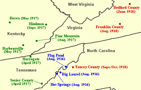
Description: Map showing some of the locations in Southern and Central Appalachia visited by British folklorist Cecil Sharp in the summers of 1916 (blue), 1917 (green), and 1918 (red). Sharp was looking for "old world" English and Scottish ballads that had been passed down to the region's inhabitants from their European ancestors. He collected hundreds of such ballads, the most lucrative areas being the Blue Ridge Mountains of North Carolina and the Cumberland Mountains of Kentucky.
Title: Cecil-sharp-appalachia-map
Credit: Own work
Author: Brian Stansberry using a U.S. National Atlas template
Usage Terms: Public domain
License: Public domain
Attribution Required?: No
Image usage
The following page links to this image:

All content from Kiddle encyclopedia articles (including the article images and facts) can be freely used under Attribution-ShareAlike license, unless stated otherwise.