
Image: Centralwashington
No higher resolution available.
Centralwashington.PNG (221 × 136 pixels, file size: 3 KB, MIME type: image/png)
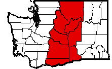
Description: Map of Central Washington created by Benjamin D. Lukoff, based on a map generated via the US Census Tiger server. Created June 7, 2004. ©2004 Benjamin D. Lukoff.
Title: Centralwashington
Credit: Own work
Author: Lukobe (talk) (Uploads)
Usage Terms: Creative Commons Attribution-ShareAlike 2.5
License: CC-BY-SA-2.5
License Link: https://creativecommons.org/licenses/by-sa/2.5/
Attribution Required?: Yes
Image usage
There are no pages that link to this image.

All content from Kiddle encyclopedia articles (including the article images and facts) can be freely used under Attribution-ShareAlike license, unless stated otherwise.