
Image: Chiaha-chiaves-map-1584
No higher resolution available.
Chiaha-chiaves-map-1584.jpg (313 × 251 pixels, file size: 23 KB, MIME type: image/jpeg)
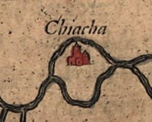
Description: Detail of the Native American village of Chiaha (spelled "Chiacha" on the map) in what is now East Tennessee, in the southeastern United States, on a 1584 map of La Florida. The map was drawn by Spanish royal cartographer Geronimo Chiaves, and was probably based on accounts by members of the Hernando de Soto expedition (1539-1543). The map was originally published in Abraham Ortelius' Theatrum Orbis Terrarum in 1584.
Title: Chiaha-chiaves-map-1584
Credit: https://www.loc.gov/exhibits/earlyamericas/online/aftermath/aftermath2.html
Author: Geronimo Chiaves, Abraham Ortelius
Usage Terms: Public domain
License: Public domain
Attribution Required?: No
Image usage
The following page links to this image:

All content from Kiddle encyclopedia articles (including the article images and facts) can be freely used under Attribution-ShareAlike license, unless stated otherwise.