
Image: Chiaves-map-xuala-1584
No higher resolution available.
Chiaves-map-xuala-1584.jpg (442 × 257 pixels, file size: 35 KB, MIME type: image/jpeg)
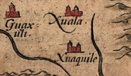
Description: Detail of the Native American village of Joara (spelled "Xuala" on the map) and two neighboring villages in what is now North Carolina, in the southeastern United States, on Chiaves' 1584 map of La Florida. The map was drawn by Spanish royal cartographer Geronimo Chiaves, and was probably based on accounts by members of the Hernando De Soto expedition (1539-1543). The map was originally published in Abraham Ortelius' Theatrum Orbis Terrarum in 1584.
Title: Chiaves-map-xuala-1584
Credit: http://www.loc.gov/exhibits/earlyamericas/online/aftermath/aftermath2.html
Author: Geronimo Chiaves, Abraham Ortelius
Usage Terms: Public domain
License: Public domain
Attribution Required?: No
Image usage
The following 3 pages link to this image:

All content from Kiddle encyclopedia articles (including the article images and facts) can be freely used under Attribution-ShareAlike license, unless stated otherwise.