
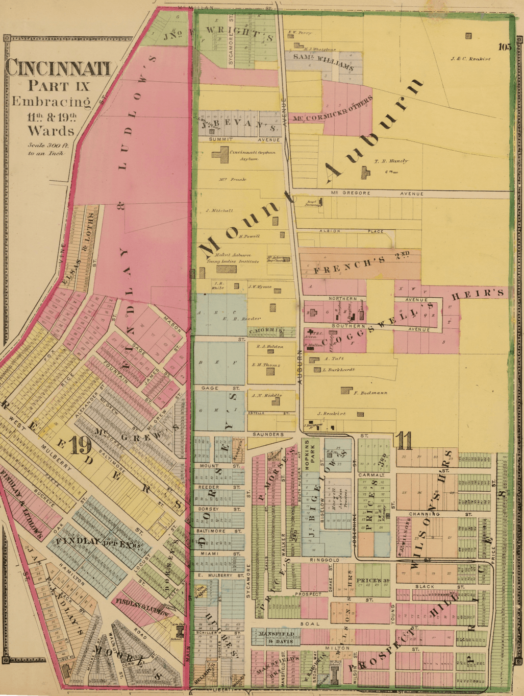
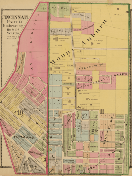
Image: Cincinnati part IX embracing 11th & 19th wards. (1869)
Description: Author: (Harrison, Robert H.; Titus, Clarence O.) Date: 1869 Short Title: Cincinnati 9, wards 11, 19. Publisher: Philadelphia: C.O. Titus Type: Atlas Map Obj Height cm: 46 Obj Width cm: 35 Scale 1: 3,600 Note: Two hand col. lithographed maps on 1 sheet. Shows numbers, tracts, owners of large parcels, major buildings, etc. State/Province: Ohio City: Cincinnati (Ohio) ; Mount Auburn (Cincinnati, Ohio) Full Title: Cincinnati part IX embracing 11th & 19th wards. (1869) List No: 3748.036 Page No: 105 Series No: 40 Engraver or Printer: Worley & Bracher ; Bourquin, F. (Frederick), b. 1808 Publication Author: Harrison, Robert H.; Titus, Clarence O. Pub Date: 1869 Pub Title: Titus' atlas of Hamilton Co., Ohio from actual surveys by R.H. Harrison, C.E. Assisted by Geo. E. Warner, A. Leavenworth, J.E. Sherman, L.C. Warner & R.T. Higgins, to which is added a township map of the state of Ohio. Also an outline & railroad map of the United States. Published by C.O. Titus. 320 Chestnut St., Philadelphia, 1869. Assistants T.F. Pratt, Cyrus Haven, H. Turner, G.P. Stevenson, J.H. Hall, D.B. Titus, G.M. Stevenson. Engd. by Worley & Bracher, 320 Chestnut St., Phila. Printed by F. Bourquin, 320 Chestnut St., Phila. Entered ... 1869 by C.O. Titus ... Pennsylvania. Pub Reference: LeGear. Atlases of the United States, 2803; Phillips, 2381; Phillips. Maps of America, p. 315; Checklist of printed maps of the Middle West to 1900, 2-1047. Pub Note: See note field above. Pub List No: 3748.000 Pub Type: County Atlas Pub Maps: 39 Pub Height cm: 48 Pub Width cm: 40 Image No: 3748036 Institution: Rumsey Collection Ownership Statement: Copyright 2007 This historical cartographic image is part of the David Rumsey Historical Map Collection, a large collection of online antique, rare, old, and historical maps, atlases, globes, charts, and other cartographic items. External links Historic Maps of Mount Auburn (Cincinnati, Ohio)
Title: Cincinnati part IX embracing 11th & 19th wards. (1869)
Permission: This work is in the public domain in its country of origin and other countries and areas where the copyright term is the author's life plus 70 years or less. You must also include a United States public domain tag to indicate why this work is in the public domain in the United States. Note that a few countries have copyright terms longer than 70 years: Mexico has 100 years, Jamaica has 95 years, Colombia has 80 years, and Guatemala and Samoa have 75 years. This image may not be in the public domain in these countries, which moreover do not implement the rule of the shorter term. Côte d'Ivoire has a general copyright term of 99 years and Honduras has 75 years, but they do implement the rule of the shorter term. Copyright may extend on works created by French who died for France in World War II (more information), Russians who served in the Eastern Front of World War II (known as the Great Patriotic War in Russia) and posthumously rehabilitated victims of Soviet repressions (more information). This file has been identified as being free of known restrictions under copyright law, including all related and neighboring rights.
Usage Terms: Public domain
License: Public domain
Attribution Required?: No
Image usage
The following page links to this image:

.png)