
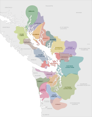
Image: Coast Salish language map

Description: Map of Coast Salish linguistic distribution in the early to mid 1800s This file was derived from:✦ Canada British Columbia location map.svg✦ USA Washington location map.svg Sources:
Map by Hillary Rudd
https://www.researchgate.net/figure/Coast-Salish-territories-drawn-by-Hillary-Rudd-2004-Thom-2005-p-61_fig3_322702552
-
Wayne Suttles Handbook of North American Indians, Volume 7, Northwest Coast, ed.(page 454):
https://www.researchgate.net/figure/Map-of-the-Central-Coast-Salish-area-showing-the-locations-of-principal-villages-in-the_fig3_322537187
-
Bill Angelbeck The Battle at Maple Bay: The Dynamics of Coast Salish Political Organization through Oral Histories
https://www.researchgate.net/figure/Map-of-Coast-Salish-territory-indicating-many-of-the-groups-mentioned-including_fig1_261943301
-
William O. Angelbeck "They recognize no superior chief" : power, practice, anarchism and warfare in the Coast Salish past
https://www.semanticscholar.org/paper/%22They-recognize-no-superior-chief%22-%3A-power%2C-and-in-Angelbeck/9026b408ccff6b4dd71431f6b6ad8adfe2e99775/figure/0
-
Unidentified map published on the University of Washington Tacoma website:
https://www.tacoma.uw.edu/sites/default/files/news/uwtnews-lushootseed-languagemap-storyimage.jpg
Author: Noahedits
Usage Terms: Creative Commons Attribution-Share Alike 3.0
License: CC-BY-SA-3.0
License Link: http://creativecommons.org/licenses/by-sa/3.0/
Attribution Required?: Yes
Image usage
The following 4 pages link to this image:
