
Image: Columbiarivermap

Size of this preview: 600 × 600 pixels. Other resolutions: 240 × 240 pixels | 1,500 × 1,500 pixels.
Original image (1,500 × 1,500 pixels, file size: 3.45 MB, MIME type: image/png)
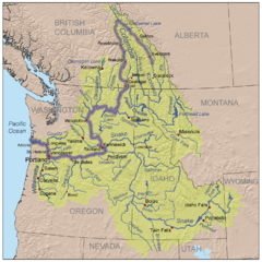
Description: This is a map of the Columbia River watershed with the Columbia River highlighted.
Title: Columbiarivermap
Credit: self-made, based on USGS and Digital Chart of the World data.
Author: Kmusser
Usage Terms: Creative Commons Attribution-Share Alike 3.0
License: CC BY-SA 3.0
License Link: http://creativecommons.org/licenses/by-sa/3.0
Attribution Required?: Yes
Image usage
The following 13 pages link to this image:
- Adams–Onís Treaty
- Canoe River (British Columbia)
- Columbia District
- Columbia River drainage basin
- David Thompson (explorer)
- Fort Nez Percés
- List of rapids of the Columbia River
- List of rivers of the Americas
- List of tributaries of the Columbia River
- Oregon Country
- Oregon boundary dispute
- Raft River Mountains
- Ruggs, Oregon

All content from Kiddle encyclopedia articles (including the article images and facts) can be freely used under Attribution-ShareAlike license, unless stated otherwise.