
Image: Columbus, ga-auburn, al metro area map

Size of this preview: 800 × 547 pixels. Other resolutions: 320 × 219 pixels | 878 × 600 pixels.
Original image (878 × 600 pixels, file size: 121 KB, MIME type: image/png)
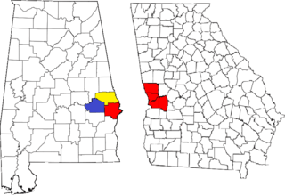
Description: Locator map of the Columbus, Georgia metropolitan area. The three components of the CSA are each colored separately: Columbus, Georgia metropolitan area: red Auburn, Alabama metropolitan area: yellow Tuskegee Micropolitan Statistical Area.
Title: Columbus, ga-auburn, al metro area map
Credit: Maps created by the United States Census Bureau
Author: United States Census Bureau, self
Usage Terms: Public domain
License: PD
Attribution Required?: No
Image usage
The following page links to this image:

All content from Kiddle encyclopedia articles (including the article images and facts) can be freely used under Attribution-ShareAlike license, unless stated otherwise.