
Image: Columbus-Marion-Zanesville CSA
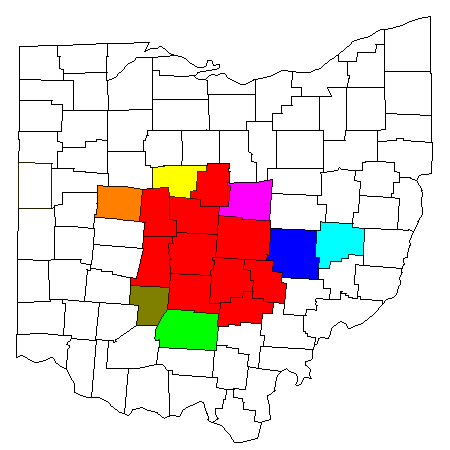
Description: Map of Columbus-Marion-Zanesville, OH Combined Statistical Area (CSA): Red: Columbus, OH MSA Yellow: Marion County, Ohio (Marion, OH µSA) Blue: Muskingum County, Ohio (Zanesville, OH µSA) Light Green: Ross County, Ohio (Chilicothe, OH µSA) Light Purple: Knox County, Ohio (Mount Vernon, OH µSA) Orange: Logan County, Ohio (Bellefontaine, OH µSA) Light Blue: Guernsey County, Ohio (Cambridge, OH µSA) Olive: Fayette County, Ohio (Washington Court House, OH µSA)
Title: Columbus-Marion-Zanesville CSA
Credit: Modified from this United States Census Bureau file, based on this Census definitions list.
Author: Yassie
Permission: US Government work is public domain. I hereby publish this image into public domain too.
Usage Terms: Public domain
License: Public domain
Attribution Required?: No
Image usage
There are no pages that link to this image.
