
Image: ConstellationGPS
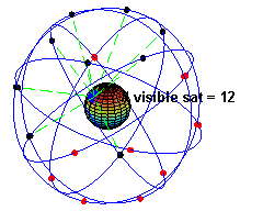
Description: A simulation of the original design of the GPS space segment, with 24 GPS satellites (4 satellites in each of 6 orbits), showing the evolution of the number of visible satellites from a fixed point (45°N) on earth (considering "visibility" as having direct line of sight). The parameters used to simulate the orbits are: eccentricity (e) 0.05, inclination (i) 55° and a separation between orbits of 60° in the right ascension of the ascending node. Within each orbit, the four satellites are evenly spaced (the instant of pass through perihelion being arbitrary for the first satellite in each orbit). The orbital period of the satellites was taken to be 12 hours. The earth was considered a perfect sphere with a radius of 6400 km. The time in the animation is running about 2880 times faster than real time (half a minute representing 24 hours), as clearly seen in the rotation of earth. The simulation was created using MATLAB and converted to animated gif format using Adobe ImageReady.
Title: ConstellationGPS
Credit: Transferred from en.wikipedia to Commons.
Author: El pak at English Wikipedia
Usage Terms: Public domain
License: Public domain
Attribution Required?: No
Image usage
The following 5 pages link to this image:
