
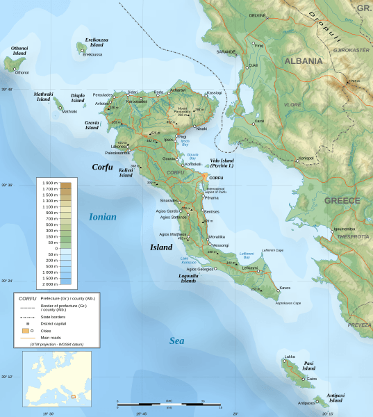
Image: Corfu topographic map-en

Description: Topographic map in English of the Corfu island area in Greece. Note : The shaded relief is a raster image embedded in the SVG file.
Title: Corfu topographic map-en
Credit: Own work ; Data sources: Topography: NASA Shuttle Radar Topography Mission (SRTM3 v.2) (public domain) edited with 3DEM from Visualization Software LLC and vectorized with Inkscape ; Bathymetry: NGDC ETOPO1 ; Locator map: Image:Europe_countries.svg (modified) created by Júlio Reis under CC-BY-SA ; Other references used for additional data: NASA World Wind ; Maps available on Corfougrece.free.fr ; Map available on Corfu-hotels.us ; Maps of Greece and Albania from the site of the University of Texas ; ViaMichelin.
Author: Eric Gaba (Sting - fr:Sting)
Permission: Attribution and Share-Alike required Any use of this map can be made as long as you credit me (Eric Gaba – Wikimedia Commons user: Sting) as the author and distribute the copies and derivative works under the same license(s) that the one(s) stated below. A message with a reply address would also be greatly appreciated.
Usage Terms: Creative Commons Attribution-Share Alike 3.0
License: CC-BY-SA-3.0
License Link: http://creativecommons.org/licenses/by-sa/3.0/
Attribution Required?: Yes
Image usage
There are no pages that link to this image.
