
Image: Crawley Neighbourhoods with Colours
No higher resolution available.
Crawley_Neighbourhoods_with_Colours.png (260 × 277 pixels, file size: 5 KB, MIME type: image/png)
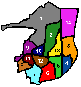
Description: Diagram of Crawley's 13 residential neighbourhoods, showing the colours used by the council on road name signs to distinguish between them. Created by Hassocks5489 based on an original diagram by Radamfi. Created 22 September 2007.
Title: Crawley Neighbourhoods with Colours
Credit: Own work Transferred from en.wikipedia
Author: Hassocks5489 at en.wikipedia
Usage Terms: Public domain
License: Public domain
Attribution Required?: No
Image usage
The following page links to this image:

All content from Kiddle encyclopedia articles (including the article images and facts) can be freely used under Attribution-ShareAlike license, unless stated otherwise.