
Image: Cyclone Nargis flooding before-and-after
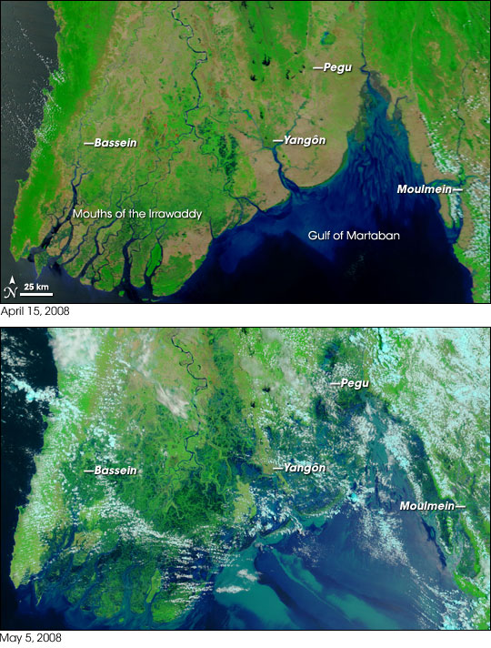
Description: Satellite photos from NASA's w:Terra satellite, showing part of w:Burma/(Myanmar) on April 15, 2008 (top) and May 5, 2008 (bottom), resulting in before-and-after comparisons of the impact from w:Cyclone Nargis. The first cyclone of the 2008 season in the northern Indian Ocean was a devastating one for Myanmar (Burma). According to reports from Accuweather.com, Cyclone Nargis made landfall with sustained winds of 130 mph and gusts of 150-160 mph, which is the equivalent of a strong Category 3 or minimal Category 4 hurricane. News reports stated that at least 10,000 people were killed, and thousands more were missing as of May 5. Flood water can be difficult to see in photo-like satellite images, particularly when the water is muddy. This pair of images from the Moderate Resolution Imaging Spectroradiometer (MODIS) on NASA’s Terra satellite use a combination of visible and infrared light to make floodwaters obvious. Water is blue or nearly black, vegetation is bright green, bare ground is tan, and clouds are white or light blue. On April 15 (top), rivers and lakes are sharply defined against a backdrop of vegetation and fallow agricultural land. The Irrawaddy River flows south through the left-hand side of the image, splitting into numerous distributaries known as the Mouths of the Irrawaddy. The wetlands near the shore are a deep blue green. Cyclone Nargis came ashore across the Mouths of the Irrawaddy and followed the coastline northeast. The entire coastal plain is flooded in the May 5 image (bottom). The fallow agricultural areas appear to have been especially hard hit. For example, Yangôn (population over 4 million) is almost completely surrounded by floods. Several large cities (population 100,000–500,000) are in the affected area. Muddy runoff colors the Gulf of Martaban turquoise. The high-resolution image provided above is at MODIS’ maximum spatial resolution (level of detail) of 250 meters per pixel. The MODIS Rapid Response Team provides twice-daily images of the region in additional resolutions and formats, including photo-like natural color. NASA images courtesy the MODIS Rapid Response Team. Caption by Rebecca Lindsey. References: BBC. (2008, May 5). Burma’s storm toll ‘nears 4,000.’ Accessed May 5, 2008. Washburn, D. (2008, May 2). Powerful Cyclone Nargis Slams Myanmar. Accuweather.com. Accessed May 5, 2008. Unisys. (2008). Cyclone Nargis, Individual Summary. 2008 Hurricane/Tropical Data for Northern Indian Ocean. Accessed May 5, 2008.
Title: Cyclone Nargis flooding before-and-after
Credit: NASA Earth Observatory
Author: MODIS Rapid Response Project at NASA/GSFC
Permission: This file is in the public domain in the United States because it was solely created by NASA. NASA copyright policy states that "NASA material is not protected by copyright unless noted". (See Template:PD-USGov, NASA copyright policy page or JPL Image Use Policy.) Warnings: Use of NASA logos, insignia and emblems is restricted per U.S. law 14 CFR 1221. The NASA website hosts a large number of images from the Soviet/Russian space agency, and other non-American space agencies. These are not necessarily in the public domain. Materials based on Hubble Space Telescope data may be copyrighted if they are not explicitly produced by the STScI.[1] See also Template:PD-Hubble and Template:Cc-Hubble. The SOHO (ESA & NASA) joint project implies that all materials created by its probe are copyrighted and require permission for commercial non-educational use. [2] Images featured on the Astronomy Picture of the Day (APOD) web site may be copyrighted. [3] The National Space Science Data Center (NSSDC) site has been known to host copyrighted content even though its photo gallery FAQ states that all of the images in the photo gallery are in the public domain.
Usage Terms: Public domain
License: Public domain
Attribution Required?: No
Image usage
The following 2 pages link to this image:
