
Image: Dalmatian Coastline near Split, Croatia

Size of this preview: 800 × 533 pixels. Other resolutions: 320 × 213 pixels | 1,440 × 960 pixels.
Original image (1,440 × 960 pixels, file size: 469 KB, MIME type: image/jpeg)
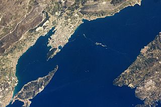
Description: In this image, a thin zone of disturbed water (tan patches) marking a water boundary appears in the Adriatic Sea between Split and the island of Brač. It may be a plankton bloom or a line of convergence between water masses, which creates rougher water.
Title: Dalmatian Coastline near Split, Croatia
Credit: NASA Earth Observatory
Author: This image was taken by the NASA Expedition 19 crew
Usage Terms: Public domain
License: Public domain
Attribution Required?: No
Image usage
There are no pages that link to this image.

All content from Kiddle encyclopedia articles (including the article images and facts) can be freely used under Attribution-ShareAlike license, unless stated otherwise.