
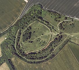
Image: Danebury Fort - aerial image, Hampshire Data Portal

Size of this preview: 679 × 600 pixels. Other resolutions: 272 × 240 pixels | 2,872 × 2,536 pixels.
Original image (2,872 × 2,536 pixels, file size: 5.57 MB, MIME type: image/jpeg)
Description: Atlas of Hillforts 3828 Danebury Fort - aerial image
Title: Danebury Fort - aerial image, Hampshire Data Portal
Credit: Hampshire Data Portal, http://hampshire.geodata.soton.ac.uk/#/, released under OGL licence; http://www.nationalarchives.gov.uk/information-management/government-licensing/about-the-ogl.htm
Author: Hampshire Hub and University of Southampton
Usage Terms: Open Government License version 1.0
License: OGL v1.0
License Link: http://NationalArchives.gov.uk/doc/open-government-licence/version/1/
Attribution Required?: Yes
Image usage

All content from Kiddle encyclopedia articles (including the article images and facts) can be freely used under Attribution-ShareAlike license, unless stated otherwise.