
Image: DaylightSaving-World-Subdivisions

Size of this preview: 800 × 401 pixels. Other resolutions: 320 × 160 pixels | 4,972 × 2,492 pixels.
Original image (4,972 × 2,492 pixels, file size: 565 KB, MIME type: image/png)
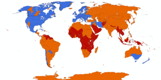
Description: English: World map showing current and past daylight saving time usage. The Spring-forward/Fall-back adjustment is a common practice at high latitudes. DST is used. DST is no longer used. DST has never been used.
Title: DaylightSaving-World-Subdivisions
Credit: based on Image:BlankMap-World-Subdivisions.PNG, plus the data in the tz database, plus data in the maps on the INMS's Time Zones & Daylight Saving Time page.
Author: Paul Eggert
Usage Terms: Creative Commons Attribution-Share Alike 3.0
License: CC-BY-SA-3.0
License Link: http://creativecommons.org/licenses/by-sa/3.0/
Attribution Required?: Yes
Image usage
There are no pages that link to this image.

All content from Kiddle encyclopedia articles (including the article images and facts) can be freely used under Attribution-ShareAlike license, unless stated otherwise.