
Image: Deepwater Horizon oil spill - May 24, 2010 - with locator

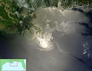
Description: Description from NASA (source): "NASA's Terra Satellites Sees Spill on May 24 Sunlight illuminated the lingering oil slick off the Mississippi Delta on May 24, 2010. The Moderate-Resolution Imaging Spectroradiometer (MODIS) on NASA’s Terra satellite captured this image the same day. Oil smoothes the ocean surface, making the Sun’s reflection brighter near the centerline of the path of the satellite, and reducing the scattering of sunlight in other places. As a result, the oil slick is brighter than the surrounding water in some places (image center) and darker than the surrounding water in others (image lower right). The tip of the Mississippi Delta is surrounded by muddy water that appears light tan. Bright white ribbons of oil streak across this sediment-laden water. Tendrils of oil extend to the north and east of the main body of the slick. A small, dark plume along the edge of the slick, not far from the original location of the Deepwater Horizon rig, indicates a possible controlled burn of oil on the ocean surface. To the west of the bird’s-foot part of the delta, dark patches in the water may also be oil, but detecting a manmade oil slick in coastal areas can be even more complicated than detecting it in the open ocean. When oil slicks are visible in satellite images, it is because they have changed how the water reflects light, either by making the Sun’s reflection brighter or by dampening the scattering of sunlight, which makes the oily area darker. In coastal areas, however, similar changes in reflectivity can occur from differences in salinity (fresh versus salt water) and from naturally produced oils from plants. Michon Scott NASA's Earth Observatory NASA Goddard Space Flight Center"
Title: Deepwater Horizon oil spill - May 24, 2010 - with locator
Credit: 1/ File:Deepwater Horizon oil spill - May 24, 2010.jpg (based upon Original image with cropping) 2/ Locator by FT2 from File:Map of USA topological.png (Public domain by author demis.nl).
Author: NASA/GSFC, MODIS Rapid Response AND demis.nl AND FT2
Permission: This file is in the public domain in the United States because it was solely created by NASA. NASA copyright policy states that "NASA material is not protected by copyright unless noted". (See Template:PD-USGov, NASA copyright policy page or JPL Image Use Policy.) Warnings: Use of NASA logos, insignia and emblems is restricted per U.S. law 14 CFR 1221. The NASA website hosts a large number of images from the Soviet/Russian space agency, and other non-American space agencies. These are not necessarily in the public domain. Materials based on Hubble Space Telescope data may be copyrighted if they are not explicitly produced by the STScI.[1] See also Template:PD-Hubble and Template:Cc-Hubble. The SOHO (ESA & NASA) joint project implies that all materials created by its probe are copyrighted and require permission for commercial non-educational use. [2] Images featured on the Astronomy Picture of the Day (APOD) web site may be copyrighted. [3] The National Space Science Data Center (NSSDC) site has been known to host copyrighted content even though its photo gallery FAQ states that all of the images in the photo gallery are in the public domain. Combined with other public domain source imagery. I as compositor of these two public domain images also release my work into the public domain - FT2
Usage Terms: Public domain
License: Public domain
Attribution Required?: No
Image usage
The following 2 pages link to this image:
