
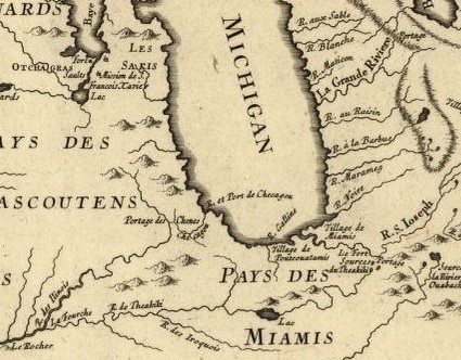
Image: Detail from a French map, published 1755, showing the Chicago Portage
No higher resolution available.
Detail_from_a_French_map,_published_1755,_showing_the_Chicago_Portage.jpg (425 × 332 pixels, file size: 97 KB, MIME type: image/jpeg)
Description: Detail from a map entitled "Partie occidentale de la Nouvelle France ou du Canada", published in 1755, that shows the “Portage des Chenes” (the portage of oak trees), that later became known as the Chicago Portage.
Title: Detail from a French map, published 1755, showing the Chicago Portage
Credit: https://www.loc.gov/resource/g3310.ar001900/?r=-0.373,-0.012,1.749,0.868,0
Author: Jacques Nicolas Bellin
Usage Terms: Public domain
License: Public domain
Attribution Required?: No
Image usage
The following page links to this image:

All content from Kiddle encyclopedia articles (including the article images and facts) can be freely used under Attribution-ShareAlike license, unless stated otherwise.