
Image: Distrito de Diu, India portuguesa

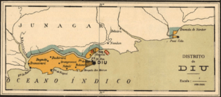
Description: Detail of a map showing the District of Diu, part of Portuguese India. It also shows the exclave of Simbor (right) where Fort St. Anthony of Simbor, also known as Forte Pani-Kota, was located. Simbor is now part of the Union Territory of Daman and Diu. This map is a detail of a larger map showing the insular and colonial possessions of Portugal and titled Portugal insular e ultramarino, which was published and republished by the Department of national education over a long period. This copy was published in the 1920s.
Title: Distrito de Diu, India portuguesa
Credit: Pinterest
Author: Department of National Education of Portugal (Educação nacional)
Usage Terms: Public domain
License: Public domain
Attribution Required?: No
Image usage
The following page links to this image:
