
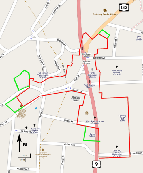
Image: Downtown Ossining Historic District map

Description: Map showing current boundaries of the Downtown Ossining Historic District, and proposed additions
Title: Downtown Ossining Historic District map
Credit: Own work
Author: Various OpenStreetMap contributors; boundary, road sign, north arrow and scale overlays added by Daniel Case
Permission: Description This map was created from OpenStreetMap project data, collected by the community. This map may be incomplete, and may contain errors. Don't rely solely on it for navigation. Author OpenStreetMap contributors Date (see file history) Source openstreetmap.org Permission (Reusing this file) OpenStreetMap data and maps are licensed under the Creative Commons Attribution-ShareAlike 2.0 license (CC-BY-SA 2.0). This file is licensed under the Creative Commons Attribution-Share Alike 2.0 Generic license. You are free: to share – to copy, distribute and transmit the work to remix – to adapt the work Under the following conditions: attribution – You must attribute the work in the manner specified by the author or licensor (but not in any way that suggests that they endorse you or your use of the work). share alike – If you alter, transform, or build upon this work, you may distribute the resulting work only under the same or similar license to this one. http://creativecommons.org/licenses/by-sa/2.0 CC BY-SA 2.0 Creative Commons Attribution-Share Alike 2.0 truetrue Georeferencing Georeference the map in Wikimaps Warper If inappropriate please set warp_status=skip to hide.
Usage Terms: Creative Commons Attribution-Share Alike 2.0
License: CC BY-SA 2.0
License Link: http://creativecommons.org/licenses/by-sa/2.0
Attribution Required?: Yes
Image usage
The following page links to this image:
