
Image: ETS2 countries

Size of this preview: 635 × 600 pixels. Other resolutions: 254 × 240 pixels | 2,625 × 2,480 pixels.
Original image (2,625 × 2,480 pixels, file size: 272 KB, MIME type: image/png)
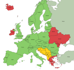
Description: As of 17 November 2021, ETS2 version 1.42.1.7s: available countries are marked green, countries under development are marked orange and red are countries which aren't yet announced. Countries, which only have a part modelled/announced are colored pale. Created with QGIS 3.20.3-Odense. CRS EPSG: 102014.
Title: ETS2 countries
Credit: Own work - based on data collected from Natural Earth.
Author: Mandula
Usage Terms: Creative Commons Attribution-Share Alike 4.0
License: CC BY-SA 4.0
License Link: https://creativecommons.org/licenses/by-sa/4.0
Attribution Required?: Yes
Image usage
The following page links to this image:

All content from Kiddle encyclopedia articles (including the article images and facts) can be freely used under Attribution-ShareAlike license, unless stated otherwise.