
Image: Early Alosta-Glendora Map

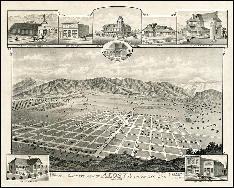
Description: Early bird's eye view of Alosta (Glendora), California from the south. The view shows the town less than 8 months after the founding of Glendora, in April 1887. The view extends from Maunaloa Avenue in the foreground to Mountain View in the west, East Seventh Street in the east and Olive Avenue in the North. The center of town is Central Avenue. This plan grid can still be seen today. Mauna Loa Avenue, Walnut Avenue and Colorado Avenue still appear on the map. Alosta Avenue or Chestnut are now Route 66. Central Avenue would appear to be Glendora Avenue. The primary image is a view from Alosta Heights looking over the town, with the railroad at the left, fruit orchards in distance and the San Gabriel Mountains beyond. The view includes inset views of the Rice Brothers Livery and Feed Stable, 2 different views of buildings on Central Avenue, S.C. (Southern California?) Hotel, a Cottage in the Le Mars Tract, the Railroad Depot, and the Residences of George E. Gard and P.O. Zeimet.
Title: Early Alosta-Glendora Map
Credit: https://www.raremaps.com/gallery/detail/23039/Birds_Eye_View_of_Alosta_Los_Angeles_Co_Cal_Jan_1888/Moore.html
Author: E.S. Moore
Usage Terms: Public domain
License: Public domain
Attribution Required?: No
Image usage
The following page links to this image:
