
Image: East-Gippsland-Rail-Trail---Profile-Map-100

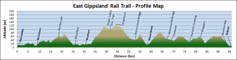
Description: Profile map of the East Gippsland Rail Trail, Victoria, Australia, showing altitude in metres against distance in kilometres. Main towns are shown in bold.
Title: East-Gippsland-Rail-Trail---Profile-Map-100
Credit: Own work by uploader. References: Victorian Railways (1927). "South Yarra to Bairnsdale and Orbost, Grades and Curve Radius" (map). East Gippsland Shire Council (2007). "East Gippsland Rail Trail". James Yeates Printing & Design. Vicroads Country Street Directory of Victoria (4 ed.). Noble Park, Victoria: Royal Automobile Club of Victoria. 2000.
Author: jjron
Permission:
Taken by John O'Neill This image has been released for use worldwide under the licensing specified below. If you require different licensing (e.g., for commercial publishing), or a larger or higher quality version of this image, it may be available from the author. You can contact the author by clicking here and leaving a message, or by sending me an email.
Usage Terms: GNU Free Documentation License 1.2
License: GFDL 1.2
License Link: http://www.gnu.org/licenses/old-licenses/fdl-1.2.html
Attribution Required?: Yes
Image usage
The following page links to this image:
