
Image: Empire & Tilden Iron Mines, MI
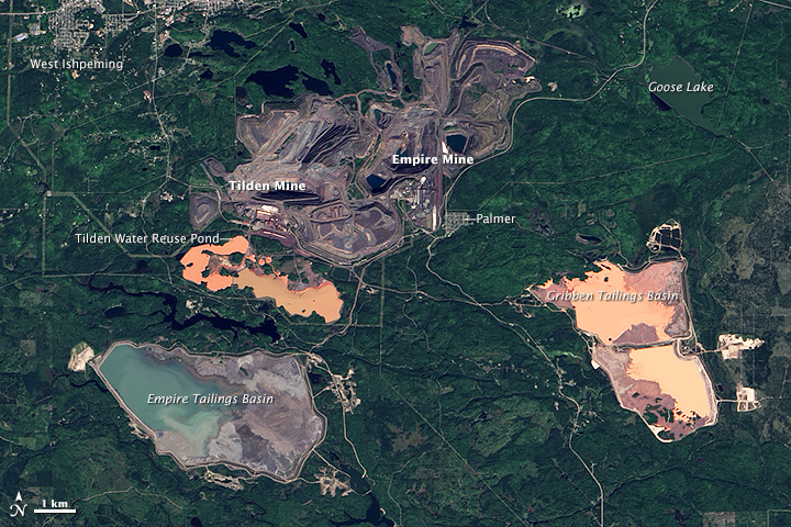
Description: The Operational Land Imager (OLI) on Landsat 8 captured this image of iron mines in northern Michigan on September 11, 2013. Although the mined areas look like one facility from a satellite perspective, there are two separate mines in this scene. The Empire Mine, which produces about 5.5 million tons of magnetite each year, is on the east side of the complex; Tilden Mine, which produces about 8 million tons of hematite and magnetite each year, is just to the west. Exposed rock and dirt in the mines appear gray compared to the surrounding forest. Large pits, piles of rock, processing facilities, roads, and railroad tracks are visible within both mines. The water in the Gribben Tailings Basin and the water reuse pond serving Tilden Mine is orange due to the high concentration of hematite, a mineral that often has a rusty brown color. In contrast, the water in the tailings basin for Empire Mine is blue because that mine only produces magnetite. You can also see Palmer and West Ishpeming, nearby towns where many mine employees live. The two mines are boons for the local economy, generating about $775 million in economic activity every year and supporting 1,600 jobs, according to Cliffs Natural Resources, the company that operates the two mines. However, the mines also have significant environmental impacts. For instance, a report released by Michigan’s Department of Environmental Quality found that sediment in Goose Lake sediment and in some nearby streams have elevated levels of selenium due to mining. Though essential to life, selenium can be toxic to wildlife in high concentrations. In response to the elevated selenium levels, environmental authorities have issued fish consumption advisories for several waterways near the mines.
Title: Empire & Tilden Iron Mines, MI
Credit: http://earthobservatory.nasa.gov/IOTD/view.php?id=84243&src=eoa-iotd
Author: NASA Earth Observatory image, Landsat data
Permission: This file is in the public domain in the United States because it was solely created by NASA. NASA copyright policy states that "NASA material is not protected by copyright unless noted". (See Template:PD-USGov, NASA copyright policy page or JPL Image Use Policy.) Warnings: Use of NASA logos, insignia and emblems is restricted per U.S. law 14 CFR 1221. The NASA website hosts a large number of images from the Soviet/Russian space agency, and other non-American space agencies. These are not necessarily in the public domain. Materials based on Hubble Space Telescope data may be copyrighted if they are not explicitly produced by the STScI.[1] See also Template:PD-Hubble and Template:Cc-Hubble. The SOHO (ESA & NASA) joint project implies that all materials created by its probe are copyrighted and require permission for commercial non-educational use. [2] Images featured on the Astronomy Picture of the Day (APOD) web site may be copyrighted. [3] The National Space Science Data Center (NSSDC) site has been known to host copyrighted content even though its photo gallery FAQ states that all of the images in the photo gallery are in the public domain.
Usage Terms: Public domain
License: Public domain
Attribution Required?: No
Image usage
The following 3 pages link to this image:
