
Image: England Wales Waterway Map Simplified

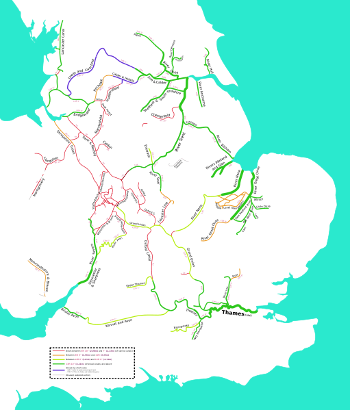
Description: * Simplified map on waterways (canalized rivers and artificial canals) of England and Wales, depicting most of the extant (navigable) rivers and canals, as well as some derelict sections that are still watered and might be reopened for navigation in the future. Canals that were abandoned long ago and exist only in a very fragmentary state (Wilts and Berks, Thames and Severn), if at all were deliberately omitted. Manchester Ship Canal, that is to this day used mainly for freight, was omitted as well due to its nature being different from the most of the rest of the British river/canal system. The map was dervied from Dr Greg's English non-metropolitan districts 2009.svg, which in turn was derived from Nilfanion's English districts 2010.svg and English ceremonial counties 2010.svg. No data from those files is present in the above map, as it was used for tracing purposes. Imperial units are used by default due to the system's history well predating metrication in the United Kingdom. Legend has units described in both feet/inches and meters.
Title: England Wales Waterway Map Simplified
Credit: This file was derived from: English non-metropolitan districts 2009.svg:
Author: map done by Ghi3000, which was based on: English non-metropolitan districts 2009.svg, created by Dr_Greg, which in turn was based on: English_districts_2010.svg, by Nilfanion, created using Ordnance Survey data, and English_ceremonial_counties_2010.svg, by Nilfanion
Usage Terms: Creative Commons Attribution-Share Alike 4.0
License: CC BY-SA 4.0
License Link: https://creativecommons.org/licenses/by-sa/4.0
Attribution Required?: Yes
Image usage
The following 2 pages link to this image:
