
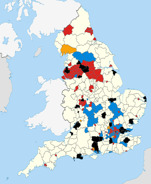
Image: English council results 2014

Size of this PNG preview of this SVG file: 494 × 600 pixels. Other resolution: 198 × 240 pixels.
Original image (SVG file, nominally 1,108 × 1,345 pixels, file size: 508 KB)
Description: Map showing the all of the Districts of England in 2010, coloured according to the results of the 2014 local elections. Equirectangular map projection on WGS 84 datum, with N/S stretched 170% Geographic limits: *West: 6.75W *East: 2.0E *North: 56.0N *South: 49.75N
Title: English council results 2014
Credit: This file was derived from English districts 2010.svg:
Author: English_districts_2010.svg: Nilfanion, created using Ordnance Survey data derivative work: Spiritofsussex
Usage Terms: Creative Commons Attribution-Share Alike 3.0
License: CC BY-SA 3.0
License Link: http://creativecommons.org/licenses/by-sa/3.0
Attribution Required?: Yes
Image usage
The following page links to this image:

All content from Kiddle encyclopedia articles (including the article images and facts) can be freely used under Attribution-ShareAlike license, unless stated otherwise.