
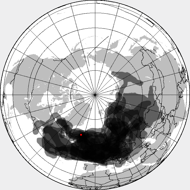
Image: Eyjafjallajökull volcanic ash composite
Description: This is a composite map showing the position of the Icelandinc volcanic ash cloud that closed European air space in different days. Based on maps found at http://www.metoffice.gov.uk/aviation/vaac/vaacuk_vag.html Days included: 14 April 2010, 12:00 UTC 14 April 2010, 18:00 UTC 15 April 2010, 18:00 UTC 16 April 2010, 18:00 UTC 17 April 2010, 18:00 UTC 18 April 2010, 18:00 UTC 19 April 2010, 18:00 UTC 20 April 2010, 18:00 UTC 21 April 2010, 18:00 UTC 22 April 2010, 18:00 UTC 23 April 2010, 18:00 UTC 24 April 2010, 18:00 UTC 25 April 2010, 18:00 UTC
Title: Eyjafjallajökull volcanic ash composite
Credit: Eyjafjallajökull_volcanic_ash_multilayer.xcf
Author: Eyjafjallajökull_volcanic_ash_multilayer.xcf: *Blankmap-ao-090N-north_pole.xcf: Reisio derivative work: Cogiati (talk) derivative work: Cogiati (talk)
Usage Terms: Creative Commons Attribution-Share Alike 3.0
License: CC BY-SA 3.0
License Link: https://creativecommons.org/licenses/by-sa/3.0
Attribution Required?: Yes
Image usage
The following page links to this image:
