
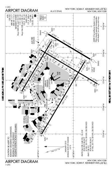
Image: FAA JFK Airport map 2011

Size of this PNG preview of this SVG file: 390 × 599 pixels. Other resolution: 156 × 240 pixels.
Original image (SVG file, nominally 605 × 929 pixels, file size: 1.36 MB)
Description: FAA diagram for John F. Kennedy International Airport in Queens, New York, United States.
Title: FAA JFK Airport map 2011
Credit: Website: http://www.avn.faa.gov/digital_tpp.asp Image: http://www.avn.faa.gov/d-tpp/0812/00610AD.PDF (changes every 28 days, see article for current link)
Author: National Aeronautical Charting Office (NACO), a department of the U.S. Federal Aviation Administration (FAA).
Permission: Public Domain
Usage Terms: Public domain
License: Public domain
Attribution Required?: No
Image usage
There are no pages that link to this image.

All content from Kiddle encyclopedia articles (including the article images and facts) can be freely used under Attribution-ShareAlike license, unless stated otherwise.