
Image: Farallon nuclear waste dumping
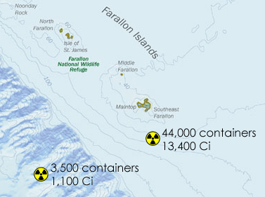
Description: Modification of Image:Cordell Bank NMS map.jpg (created by NOAA) with general locations of nuclear waste dumping sites indicated. Over time many of the drums have moved and are not as isolated as these sites indicate; additionally it is potentially the case that some of the waste was never dropped at the exact locations to begin with. According to a 1980 report by the Environmental Protection Agency, approximately 47,500 containers, 55 gallon steel drums, were dumped in the vicinity of the Farallones, with a total estimated radioactive activity of 14,500 Ci. All but 3,500 of these were dumped at 37º37'N, 123º17'W; the rest were dumped at 37º38'N, 123º08'W. These two locations are indicated on the map above.
Information on the dumping comes from: U.S. Environmental Protection Agency, Radioactive Waste Dumping Off the Coast of California, Fact Sheet (14 August 1980).
The little radioactive signs are from Image:Radiation warning symbol.svg, which is licensed as PD-self.
Usage Terms: Public domain
Image usage
The following page links to this image:
