
Image: Fergana valley topo political
No higher resolution available.
Fergana_valley_topo_political.png (375 × 178 pixels, file size: 47 KB, MIME type: image/png)
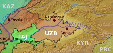
Description: Map of the Fergana valley (highlighted) in Central Asia, national territories color coded, with shortened names, using boundaries from CIA 2001 Map File:Tajikistan_2001_CIA_map.jpg
Title: Fergana valley topo political
Credit: Syrdaryamap.png
Author: Syrdaryamap.png: Background layer attributed to DEMIS Mapserver, map created by Shannon1 derivative work: T L Miles (talk)
Usage Terms: Creative Commons Attribution-Share Alike 3.0
License: CC BY-SA 3.0
License Link: https://creativecommons.org/licenses/by-sa/3.0
Attribution Required?: Yes
Image usage
The following page links to this image:

All content from Kiddle encyclopedia articles (including the article images and facts) can be freely used under Attribution-ShareAlike license, unless stated otherwise.