
Image: Fertile Crescent map

Size of this preview: 488 × 600 pixels. Other resolutions: 195 × 240 pixels | 1,988 × 2,443 pixels.
Original image (1,988 × 2,443 pixels, file size: 717 KB, MIME type: image/png)
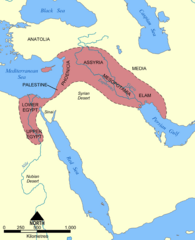
Description: This map shows the location and extent of the Fertile Crescent, a region in the Middle East incorporating Ancient Egypt; the Levant; and Mesopotamia.
Title: Fertile Crescent map
Credit: Own work This image was based on a similar map from the 1994 edition of the Encyclopedia Britannica.
Author: User:NormanEinstein
Usage Terms: Creative Commons Attribution-Share Alike 3.0
License: CC-BY-SA-3.0
License Link: http://creativecommons.org/licenses/by-sa/3.0/
Attribution Required?: Yes
Image usage
The following page links to this image:

All content from Kiddle encyclopedia articles (including the article images and facts) can be freely used under Attribution-ShareAlike license, unless stated otherwise.