
Image: Florida-Pensacola-map-legend-X-6-1756-FAA
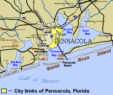
Description: City map of Pensacola, with city limits marked by legend (see References maps). The site of the first settlement near Pensacola (Ochuse) is marked by the red "X" near the site of Fort Barrancas. Small crosses designate airfields in the region. Areas have been labeled for the communities of Brent, West Pensacola, Warrington, Gulf Breeze, and Pensacola Beach. (Several other towns have not been labeled.)
Title: Florida-Pensacola-map-legend-X-6-1756-FAA
Credit: (Original text: Source URL (U.S. Government FAA): http://tfr.faa.gov/save_maps/map_6_1756.gif (Airfield map trimmed/edited to set Pensacola city limits, label "Santa Rosa Island" (below site marked "X") plus Interstate-10/110 icons, "Pensacola Bay" and other bays). The file is in GIF format, which can be edited in detail without loss of colors. References Pensacola area map, SoutheastRoads.com, 2007, webpage: SERoads-pensacola_map.gif. FAA area airfields map, webpage: FAAgov-map_6_1756.gif.)
Usage Terms: Public domain
License: Public domain
Attribution Required?: No
Image usage
The following 8 pages link to this image:
