
Image: Formation of Massachusetts towns

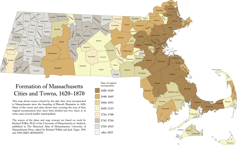
Description: This map shows towns colored by the date they were incorporated in the United States state of Massachusetts since the founding of Plimoth Plantation in 1620. Many of the towns and cities shown here covering the area of their original incorporation have since been divided into two, three or in some cases several smaller municipalities. The shorelines and state boundaries have also been adjusted over the years; the modern shoreline and borders are shown here anachronistically. Some towns originally incorporated in Massachusetts are now in Connecticut or Rhode Island.
Title: Formation of Massachusetts towns
Credit: Own work by uploader: dates, town boundaries and map concept are based on work by Richard Wilkie, Ph.D. of the University of Massachusetts Amherst, published in the Historical Atlas of Massachusetts, University of Massachusetts Press, edited by Richard Wilkie and Jack Tager, 1991 and 1993, ISBN: 0870236970 (website). Outline map using Quantum GIS and Inkscape based on public data from Office of Geographic and Environmental Information (MassGIS), Commonwealth of Massachusetts Executive Office of Environmental Affairs - http://www.mass.gov/mgis/dd-over.htm This graphic was created with QGIS This vector image was created with Inkscape.
Author: Sswonk
Usage Terms: Creative Commons Attribution-Share Alike 3.0
License: CC BY-SA 3.0
License Link: http://creativecommons.org/licenses/by-sa/3.0
Attribution Required?: Yes
Image usage
The following 3 pages link to this image:
