
Image: Fort Detroit and flanking ribbon farms

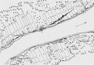
Description: Detail from a copy of a 1798 map, that shows ribbon farms flanking Fort Detroit and across the river at what is now Windsor, Canada. The concept originated with "Ribbon Farms", some dating back to the time of Antoine Cadillac's founding of Fort Pontchartrain du Détroit, in July 1701.
Title: Fort Detroit and flanking ribbon farms
Credit: "Plan Topographique du Détroit et des Eaux qui formet la jonction du Lac Erié avec le Lac St. Claiv. ... Drawn from a Copy in the "Burton Collection" at Detroit, Michigan, by F. Leesemann & M.A. Heinze, Draftsmen, U.S. Engineer Office, Detroit, Mich." ... "The original Map, of which this is a copy, was made in 1798, under direction of General George Henry Victor Collot, an officer in the army of Napoleon. ... The original map was, until recently, hanging in the Department of Marine in the city of Paris, and a description of it is given in Parkman's Conspiracy of Pontiac. /s/ C. M. Burton" — image now at https://historicalcharts.noaa.gov/image=00-00-1796 via https://historicalcharts.noaa.gov/ as of 2020 http://www.atdetroit.net/forum/messages/6790/91521.html?1180288955 ("Here are a few enlargements from the 1796 French map from the NOAA historical map section that I linked to above. It took awhile to get them done, as I can only view them in an IE plugin, and then do a print screen into PS, adding an extra step into it.")
Author: F. Leesemann & M.A. Heinze, Draftsmen, U.S. Engineer Office, Detroit, Mich.
Permission: PD: U.S. government copy of 1798 map
Usage Terms: Public domain
License: Public domain
Attribution Required?: No
Image usage
The following page links to this image:
