
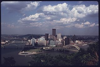
Image: GOLDEN TRIANGLE SHOWN FROM THE MT. WASHINGTON AREA. IT WAS GIVEN THE NEW REFERENCE IN THE EARLY 1950'S DURING THE... - NARA - 557273

Size of this preview: 800 × 541 pixels. Other resolutions: 320 × 216 pixels | 3,000 × 2,027 pixels.
Original image (3,000 × 2,027 pixels, file size: 640 KB, MIME type: image/jpeg)
Title: GOLDEN TRIANGLE SHOWN FROM THE MT. WASHINGTON AREA. IT WAS GIVEN THE NEW REFERENCE IN THE EARLY 1950'S DURING THE URBAN RENEWAL RENAISSANCE PROGRAM. THE TRIANGLE IS FORMED WHERE THE ALLEGHENY AND MONONGAHELA RIVERS MEET TO FORM THE OHIO RIVER
Credit: U.S. National Archives and Records Administration
Author: Alexandrowicz, John L., Photographer (NARA record: 8452213)
Usage Terms: Public domain
License: Public domain
Attribution Required?: No
Image usage
The following page links to this image:

All content from Kiddle encyclopedia articles (including the article images and facts) can be freely used under Attribution-ShareAlike license, unless stated otherwise.