
Image: Gwadar satellite view

Size of this preview: 600 × 600 pixels. Other resolutions: 240 × 240 pixels | 2,000 × 2,000 pixels.
Original image (2,000 × 2,000 pixels, file size: 636 KB, MIME type: image/jpeg)
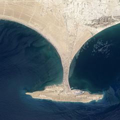
Description: This image shows the area before Zalzala Jazeera (Earthquake Island) surfaced in the upper left quadrant of this image of Gwadar, Pakistan. File:Gwadar satellite view showing island created by 2013 earthquake.jpg shows the same view with the island.
Title: Gwadar satellite view
Credit: http://earthobservatory.nasa.gov/NaturalHazards/view.php?id=82146
Author: NASA
Usage Terms: Public domain
License: Public domain
Attribution Required?: No
Image usage
The following page links to this image:

All content from Kiddle encyclopedia articles (including the article images and facts) can be freely used under Attribution-ShareAlike license, unless stated otherwise.