
Image: HUC 0313000105 to 07 topographic map - Chestatee River areaf

Size of this JPG preview of this TIF file: 362 × 599 pixels. Other resolution: 145 × 240 pixels.
Original image (568 × 940 pixels, file size: 675 KB, MIME type: image/tiff)
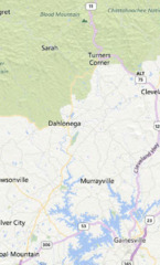
Description: HUC 0313000105 to 07 topographic map - Map showing the Chestatee River area, with its source near Blood Mountain, running south near Turners Corner and through Dahlonega, and flowing into Lake Lanier at the southern part of the map.
Title: HUC 0313000105 to 07 topographic map - Chestatee River area
Credit: http://watersgeo.epa.gov/mwm/?layer=LEGACY_WBD&feature=03130001&extraLayers=null?layer=LEGACY_WBD&feature=03130001&extraLayers=null
Author: EPA
Usage Terms: Public domain
License: Public domain
Attribution Required?: No
Image usage
The following page links to this image:

All content from Kiddle encyclopedia articles (including the article images and facts) can be freely used under Attribution-ShareAlike license, unless stated otherwise.