
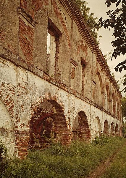
Image: Hacienda Azurarera Santa Elena, Sugar Mill Ruins, 1.44 miles North of PR Route 2 Bridge Over Rio De , Toa Baja (Toa Baja County, Puerto Rico)

Description: Hacienda Azurarera Santa Elena, Sugar Mill Ruins, 1.44 miles North of PR Route 2 Bridge Over Rio De , Toa Baja (Toa Baja County, Puerto Rico) cropped This image or media file contains material based on a work of a National Park Service employee, created as part of that person's official duties. As a work of the U.S. federal government, such work is in the public domain in the United States. See the NPS website and NPS copyright policy for more information. Creator: U.S. Department of the Interior, National Park Service, Historic American Engineering Record. Survey number HAER PR,75-TOBA,1A-52 Source: U.S. Library of Congress, Prints and Photographs Division, "Built in America" Collection. Copyright: "The original measured drawings and most of the photographs and data pages in HABS/HAER/HALS were created for the U.S. Government and are considered to be in the public domain."
Title: Hacienda Azurarera Santa Elena, Sugar Mill Ruins, 1.44 miles North of PR Route 2 Bridge Over Rio De , Toa Baja (Toa Baja County, Puerto Rico)
Credit: http://memory.loc.gov/pnp/habshaer/pr/pr0000/pr0023/color/571274cv.jpg
Author: Jack Boucher
Usage Terms: Public domain
License: Public domain
Attribution Required?: No
Image usage
The following image is a duplicate of this image (more details):
.jpg)
The following 2 pages link to this image:

.jpg)