
Image: Hawaii Volcanoes Hazard Map

Size of this PNG preview of this SVG file: 310 × 335 pixels. Other resolution: 222 × 240 pixels.
Original image (SVG file, nominally 310 × 335 pixels, file size: 174 KB)
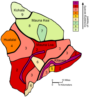
Description: The Island of Hawaiʻi was mapped into 9 lava flow hazard zones meant to portray the future long-term hazard due to lava flow activity.
Title: Hawaii Volcanoes Hazard Map
Credit: Upconverted SVG based on File:USGS Hawaii Island Lava Hazard Map.gif
Author: Resident Mario (talk) This vector image was created with Inkscape.
Usage Terms: Public domain
License: Public domain
Attribution Required?: No
Image usage
The following page links to this image:

All content from Kiddle encyclopedia articles (including the article images and facts) can be freely used under Attribution-ShareAlike license, unless stated otherwise.