
Image: HistorySixWeeksTourMap
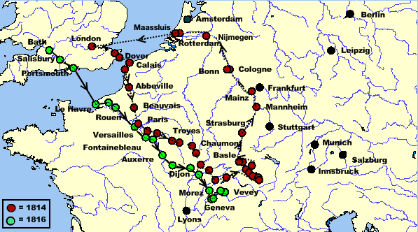
Description: A map of the 1814 and 1816 journeys taken by Mary Shelley, Percy Shelley, and Claire Clairmont. Based on the map found in The Novels and Selected Works of Mary Shelley. Vol. 8. Ed. Jeanne Moskal. London: William Pickering, 1996, pg. 10. The 1814 trip is represented by a dotted line and the 1816 trip is represented by a solid line. Green dots indicate towns visited or stayed at during the 1816 trip, which ended in a three-month stay at Lake Geneva. Red dots indicate towns visited or stayed at during the 1814 trip. Black dots indicate towns not visited but perhaps helpful to the reader. The source map does not indicate what route the Shelleys used on the return trip to England for the 1816 trip.
Title: HistorySixWeeksTourMap
Credit: Own work by Awadewit, made with Online Map Creation, (which uses GMT,[1] an open source software licensed under GNU GPL[2])
Author: Awadewit
Usage Terms: Creative Commons Attribution-Share Alike 3.0
License: CC BY-SA 3.0
License Link: http://creativecommons.org/licenses/by-sa/3.0
Attribution Required?: Yes
Image usage
The following page links to this image:
