
Image: Hmw-Taal-2020112-2020113
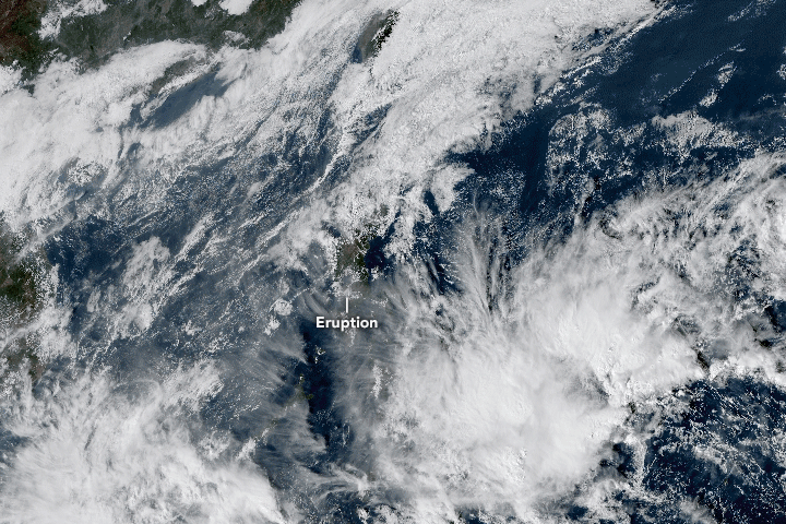
Description: In January 2020, the Taal Volcano in the Philippines spewed lava and emitted hazardous amounts of volcanic ash fall and gases. The time-series animation above shows the growth and spread of the volcanic plume from January 12-13, as observed by Japan’s Himawari-8 satellite. The volcano first unleashed a steam-driven explosion (known as a phreatic eruption) on January 12. In the early morning of January 13, eruptive activity increased and the volcano emitted a fountain of lava for about an hour and a half. According to the Philippine Seismic Network, at least 144 volcanic earthquakes have been recorded since January 12, suggesting continuous magmatic activity underneath Taal and potentially more eruptive activity. According to news reports, the eruption of Taal lofted ash fall up to 14 kilometers (9 miles) into the air. The eruption was accompanied by intense thunder and lightning above the summit. Winds carried volcanic ash fall north across Luzon. Taal is the second-most active volcano near Manila, which is located approximately 60 kilometers (40 miles) north of the volcano. In total, ten cities and municipalities surround Taal. The Philippine Institute of Volcanology and Seismology (PHIVOLCS) has ordered a “total evacuation” for people in high-risk areas within a 14-kilometer radius from the main crater, affecting around half a million people. Instruments used for this image: Himawari-8 and Suomi NPP — OMPS
Title: Hmw-Taal-2020112-2020113
Credit: https://earthobservatory.nasa.gov/images/146142/sulfur-spews-from-taal
Author: NASA Earth Observatory image by Lauren Dauphin, using OMPS data from the Goddard Earth Sciences Data and Information Services Center (GES DISC). Natural-color animation based on Himawari imagery, courtesy of the Japan Meteorological Agency .
Permission: Use of NASA logos, insignia and emblems is restricted per U.S. law 14 CFR 1221. The NASA website hosts a large number of images from the Soviet/Russian space agency, and other non-American space agencies. These are not necessarily in the public domain. Materials based on Hubble Space Telescope data may be copyrighted if they are not explicitly produced by the STScI.[1] See also Template:PD-Hubble and Template:Cc-Hubble. The SOHO (ESA & NASA) joint project implies that all materials created by its probe are copyrighted and require permission for commercial non-educational use. [2] Images featured on the Astronomy Picture of the Day (APOD) web site may be copyrighted. [3] The National Space Science Data Center (NSSDC) site has been known to host copyrighted content. Its photo gallery FAQ states that all of the images in the photo gallery are in the public domain "Unless otherwise noted."
Usage Terms: Public domain
License: Public domain
Attribution Required?: No
Image usage
The following page links to this image:
